
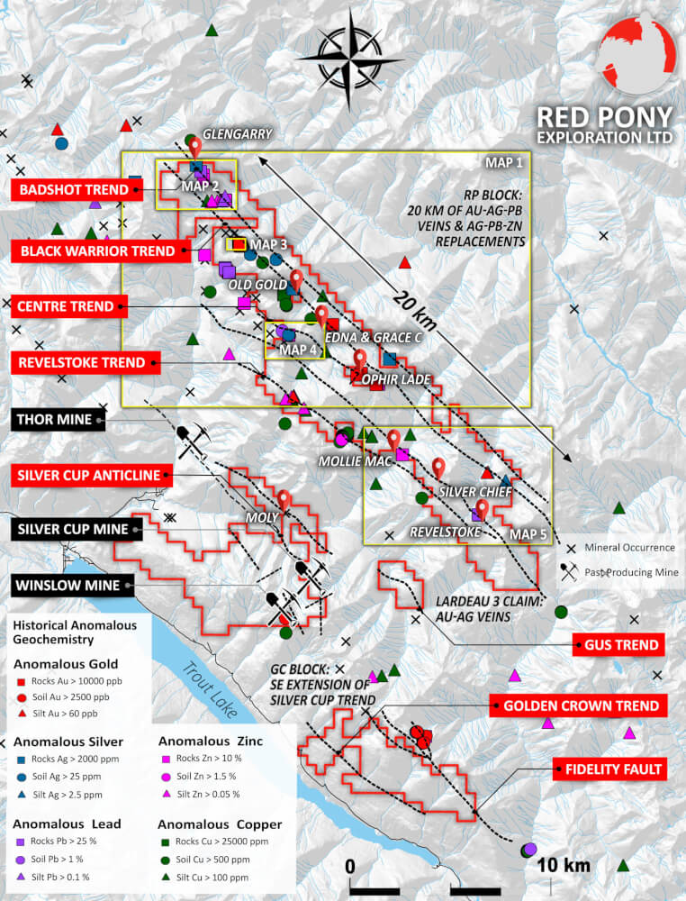
VANCOUVER, British Columbia, September 24, 2021 – Red Pony Exploration Ltd. (“Red Pony” or the “Company”) is pleased to announce results from recently compiled historic rock, silt and soil geochemical data on its wholly owned Trout Lake Project (the “Trout Lake Project”), located in southeast British Columbia, Canada. The compilation shows that high-grade precious and base metal mineralization occurs primarily along property- to regional-scale northwest trending linear features.
Highlights:
- Historic rock samples along the Badshot Trend grade include the Glengarry prospect with samples containing up to 1768 g/t silver and 69.5% lead.
- The Black Warrior trend contains anomalous gold values in quart-sulphide veins Highlights near the Old Gold prospect include: sample RMK8113 with 4.56 g/t gold, 112 g/t silver, and 29.4% zinc; sample RMK8121 with 0.66 g/t gold, 12,147g/t silver, and 10.7% Cu. Historic rocks from the Edna and Grace showing 2km to the southeast returned values of 6 g/t gold, 649.4 g/t silver and 4.9% zinc.
- Along the Revelstoke Trend, historic rock samples at the Revelstoke prospect grade up to 475 g/t silver and 49% lead; this trend continues 5km to the northwest through the Silver Chief prospect (not included in this compilation) to the Mollie Mac showing with rock samples containing 138.9 g/t silver and 30% combined lead-zinc.
Program Details:
The compiled historic data includes a total of 1,220 rock, 5,737 soil, and 548 silt samples located on or near the claims owned by Red Pony. Many of the rock and soil geochemical anomalies contribute to the definition of prominent northwest-trending linear features or trends along which precious and base metal prospects are known to occur. These linear features include the Badshot Trend, Black Warrior Trend, Centre Trend and Revelstoke Trend.
The compiled historic rock, soil and silt samples are shown on the accompanying master map and select highlights are listed in the table below. A link (redponyexploration.com/news-release/) provides access to a suite of more detailed maps of the Company’s Trout Lake Project. This is the first time all of the historic data has been compiled and put into a visual format.
Zaccheri Gray, President of Red Pony stated: “The newly compiled data shows that mineralization has been found in multiple northwest-trending belts over the full 20km length of our 100%-owned RP claim block. The data is impressive and clearly shows high-grade silver, lead and zinc values locally with important levels of gold and copper. The higher grades occur in semi-massive to massive sulphide mineralization consistent with a carbonate replacement deposit model. Polymetallic quartz-carbonate veins, similar to those on our majority-owned at Winslow property to the west, also occur locally. The recognition of the distribution and tenor of mineralization is very encouraging and forms a baseline for accelerated exploration on these exciting targets.”
Figure 1: Simplified compilation map showing significant linear features and distribution of gold, silver, lead, zinc, and copper anomalies on and near the RP claim block.
| Sample ID | Date Sampled | Prospect | Au g/t | Ag
g/t |
Cu % | Pb % | Zn % | Rock Description |
| BADSHOT TREND | ||||||||
| RMK8012 | 2008-08-22 | Glengarry | 0.00 | 1768.0 | 0.0 | 69.5 | 5.2 | Coarse-grained galena with quartz and dolomite; 70% galena. |
| RMK8056 | 2008-09-07 | Glengarry | 0.02 | 1340.0 | 0.1 | 71.6 | 0.7 | Quartz vein 6cm thick. 60% galena. Near tunnel. |
|
BLACK WARRIOR TREND |
||||||||
| RMK8095 | 2008-09-10 | Old Gold | 0.17 | 22.7 | 16.7 | 0.0 | 0.0 | White quartzite/sericite (2x6x4cm). Abundant malachite in sericite. Quartzite with 40% pyrrhotite. |
| RMK8110 | 2008-09-11 | Old Gold | 0.06 | 9.8 | 2.4 | 0.0 | 0.0 | Sericite schist with abundant malachite. 4% brown sulphide (pyrrhotite?). |
| RMK8113 | 2008-09-12 | Old Gold | 4.56 | 112.0 | 0.3 | 0.1 | 29.4 | Banded quartz-sulphide vein (15x30x40cm). with centimetre-thick layers of massive sphalerite. Orange rind. Up to 50% sphalerite, trace chalcopyrite, trace galena. |
| RMK8119 | 2008-09-12 | Old Gold | 0.67 | 2200.0 | 0.6 | 19.7 | 21.6 | Banded quartz-sulphide vein (4x10x15cm); bands up to 10cm thick of 30% sphalerite & 20% galena. |
| RMK8120 | 2008-09-12 | Old Gold | 2.26 | 260.2 | 0.1 | 18.0 | 20.0 | Banded quartz-sulphide vein (15x20x40cm) with 10cm thick band of sphalerite-galena. Orange-grey rind. |
| RMK8121 | 2008-09-12 | Old Gold | 0.66 | 12147.0 | 10.7 | 3.3 | 1.2 | Crudely banded quartz-carbonate-sulphide vein (13cm thick). Abundant sulfosalts; drusy quartz. Brown rind. |
| RMK6027 | 2006-01-01 | Edna and Grace | 6.00 | 649.4 | 0.3 | 5.7 | 4.9 | 40% oxidized with 10% m-gr sulphides (tetrahedrite, chalcopyrite). |
|
CENTRE TREND |
||||||||
| 21145 | 1988-09-01 | Ophir Lade | 29.83 | NA | NA | NA | NA | Massive sulphide; Lade adit. |
| 21148 | 1988-09-01 | Ophir Lade | 13.92 | NA | NA | NA | NA | Composite: west end of Lade vein. |
| 8R203654 | 2008-01-01 | Ophir Lade | 1.07 | 338.0 | 0.2 | 11.2 | 14.8 | Adit quartz vein. |
| 8R203655 | 2008-01-01 | Ophir Lade | 0.34 | 256.0 | 0.1 | 9.8 | 12.8 | Footwall of Adit quartz vein. |
|
REVELSTOKE TREND |
||||||||
| RED-001 | 1985-01-01 | Revelstoke | 0.09 | 224.9 | NA | 35.0 | 0.1 | Trench sample: massive, coarse grained galena with minor pyrite. |
| RED-002 | 1985-01-01 | Revelstoke | 0.09 | 474.5 | NA | 49.0 | 0.0 | Trench sample: massive galena- pyrite. |
| RMK1019 | 1985-01-01 | Mollie Mac | 0.07 | 138.9 | 0.01 | 15.7 | 15.7 | WHITE CRYS LIMESTONE |
The metal values used in the AgEq calculation are in US dollars: Ag: $25/oz, Au: $1750/oz, Cu: $4.20/lb, Pb: $0.90/lb, Zn: $1.30/lb. AgEq calculation: (Ag g/t + Au g/t x 70 + Cu% x 115.201 + Pb* x 24.686 + Zn + 35.676)
Next Steps:
The Company’s wholly owned Trout Lake Project, and the adjacent majority-owned Winslow Project, is being explored by field geologists who are locating, mapping and sampling known prospects as well as the mineralized trends along which they occur.
Quality Assurance and Control
This comprehensive dataset, including results for gold, silver, lead, zinc and copper, was compiled by Tripoint Geological Services Ltd. and includes all available current and historical data.
The data and results provided in this news release were assembled from the BC Geological Survey Branch’s ARIS (Assessment Report Indexing System) including technical assessment reports and data from mineral exploration that took place in and around the Trout Lake Project.
Digital data was not readily available for many of the reports; therefore OCR software was used to extract drill hole information, surface sample locations and analytical results. This data was checked for errors and formatted into an excel template before being imported into a DataShed Database. A confidence level of 1 to 5 was used to denote the quality of the original report data, 1 being the lowest confidence and 5 being the highest confidence as some reports were missing key information such as locations of samples. The importing process flags any errors such as incorrect codes, overlapping samples or duplicate sample ID’s which were fixed by going back to the source data, verifying the correct value or adding a note to the database where the source data was missing the required information. Detailed spatial checks were completed to reduce any potential location errors. Due to the nature of the data, the assay certificate, laboratory, analytical method and results were imported into the database when that information was available in the source data.
The technical content of this news release has been reviewed and approved by “Robert A. (Bob) Lane, P.Geo., a qualified person as defined by National Instrument 43-101.
About Red Pony Exploration:
Red Pony Exploration is a Canadian exploration company based in Vancouver BC with several large-scale land packages in and around British Columbia’s world-famous Silver Cup Ridge.